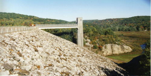
Photo and information courtesy of the Town of Thomaston.
The Thomaston Dam, a US Army Corp of Engineers flood control project, was constructed in 1960 at an estimated cost of $14 million. The Dam is located in the towns of Thomaston, Harwinton, Litchfield, and Plymouth. In addition to flood control, the 849 acres of land and water resources provide many recreational opportunities including hiking, sightseeing, snowmobiling, fishing, and upland hunting.
Naugatuck River Flood Control Projects
Due to the steep gradient of the main stem and the many short, steep tributaries, runoff from precipitation is rapid and the river is prone to floods. The record flood occurred in 1955 resulting in the loss of 47 lives, and an estimated $245 million in damages. In the years following the 1955 flood, the U.S. Army Corps of Engineers undertook extensive flood control projects in the basin. The threat of devastating floods has been greatly minimized because of these control measures.
Why So Much Flooding?
One of the unique aspects of the Naugatuck is its connection to many rapidly flowing, smaller rivers and streams that enter the valley between Torrington and Derby. Because of this geographic characteristic, the Naugatuck River has had a high potential for flooding. In most rivers the magnitude of the flood peaks usually depends on volume, not intensity of flow. But the quick development of floods on the N
augatuck is due to the numerous short, steep streams emptying into the river almost simultaneously. In major floods – like in 1955 – the river becomes very volatile, cresting within a very short period of time along its entire length.
Since the flood of 1955, however, federal flood control programs have been put in place. A large flood control dam was constructed on the main stem of the river at Thomaston and six additional flood control dams were constructed on tributaries. Along with the Thomaston Dam, the smaller Hall Meadow Brook, East Branch, Northfield Brook, Black Rock, Hancock Brook, and Hop Brook Dams provide a total flood capacity of 77,000 acre feet. Five local flood control projects were also constructed, resulting in extensive stream channel modifications in the Cities of Torrington, Waterbury, Ansonia and Derby.

Sources of information:
Connecticut Department of Environmental Protection, Bureau of Water Management. April 1992. Naugatuck River Fact Sheet.
Housatonic Valley Association. Winter 1991. Reviving the Naugatuck River. Article printed in the Winter 1991 HVA Current.
